Well, Monday did not live up to its potential. I had a wonderful trip and saw some great storm structure with friends, but there were no tornadoes. In my previous blog post, I mentioned uncertainty was very high - so the bust wasn't a complete surprise. But I thought that Southern Minnesota would at least have a little more activity. While they indeed saw some storms, they quickly turned linear instead of persisting as discrete supercells. Linear bands of storms tend to produce very weak tornadoes (if they produce at all) because they do not have a well-defined inflow region where moist, sheared air can be ingested into the storm. More specifically, this lack of inflow prevents them from ingesting streamwise vorticity, which is critical for creating a rotating updraft (mesocyclone) and tornado.
Vertical wind shear translates to streamwise vorticity, updrafts tilt this vorticity into the vertical to create a strong rotating updraft (mesocyclone). If this rotating updraft stretches and extends to the surface, you get a tornado.
Credit: Dr. Richard Bernatz, professor of mathematics, Luther College in Decorah, Iowa
Our Route
I left downtown Ames around 2pm with Tyreek Frazier - a current PhD student with Dr. Bill Gallus, and Dylan McDermott, a recently-graduated masters student with Dr. Ian Williams who now works as a weather & catastrophe analyst. We headed north to Clear Lake and got there around 3:20, meeting up with several other atmospheric science grad students at Iowa State. We stayed at Clear Lake for about an hour looking at current conditions before deciding to head west towards Algona (the "IHOP") in the map below, arriving there at 5 and continuing to watch storms develop until 5:50. After that, we decided to chase a line of storms developing to our west, driving through Pur and Bancroft on highway 169, Buffalo Center on highway 9, Lake Mills on highway 69, before stopping at Diamond Jo Casino & Hotel around 8pm to regroup. From there, we decided to take one last look at storms near Kensett (~1515 400th St.), and then grabbed dinner in Mason City around 9pm. After Mason City, we drove back to Ames along I-35, getting back home around 10:40 pm. In total, we did about 343 miles of driving over 6 1/2 hours... not the most I've driven for a storm chase, which if you can believe it is actually pretty low for a chase day!

Part 1: The Drive - Ames to Algona
The first tornado warning of the day was issued at 2:34 pm for SW Minnesota, slightly north of Windom. This is associated with a line of thunderstorms that began developing shortly after noon near the storm's "triple point."
 Credit: National Weather Service
The triple point is where the occluded front, cold front, and warm front all meet. The triple point is an ideal spot for storm initiation because it is close to the low center, resulting in increased atmospheric lift due to upper-level divergence aloft, and it is at the meeting at several fronts, resulting in surface convergence and dynamic uplift.

Credit: College of Dupage
Our rationale for staying in Clear Lake for an hour was to watch these storms develop further and see if any of them disconnected from the line and turned "discrete." Discrete cells have both better visibility compared to linear storms and - as mentioned above - have better inflow and are able to ingest more streamwise vorticity. The HRRR (High-Resolution-Rapid-Refresh) showed a few discrete cells developing over north-central Iowa around 6pm, and we didn't want to chase a line of storms only for some supercells to drop right over where we previously were. I've been there, done that on previous trips, and let me tell you - it is not a good feeling! I've highlighted those discrete cells with the red circle below.
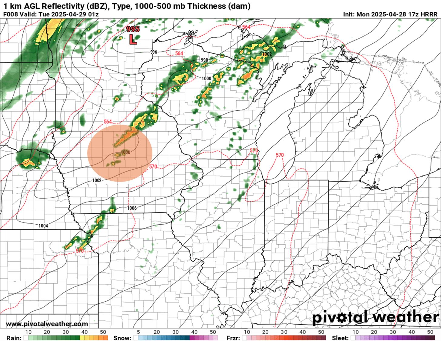
Credit: pivotalweather.com
After some discussion, we headed west on highway 18 to Algona. Our rationale was that some of the storms at the southern tip of the front, where inflow is more robust, had a chance of becoming tornadic and would have better visibility, and we didn't have confidence that the "capping inversion" - mentioned in my previous blog - would break and we'd see discrete storms over Clear Lake.
The SPC mesoanalysis chart below shows temperature (gold & red lines), dewpoint (blue dashed lines & shaded area), and isobars (black lines), with radar imagery overlaid. Note the band of storms extending from the beginning of the dryline over Western Iowa up to the Triple Point in Southern Minnesota, as well as the dewpoints in the mid-upper 60s (shaded green area) throughout the warm sector. We wanted to stay in that area of higher dewpoints, as that region had the best instability and parameters for large supercells.
0
Credit: Storm Prediction Center
Driving to Algona, we encountered blowing dust with surface winds of 30-40 mph blowing over the freshly plowed fields that are getting set for planting corn and soybeans.

Taken 4:39 pm driving west along Hwy 18, near Britt IA
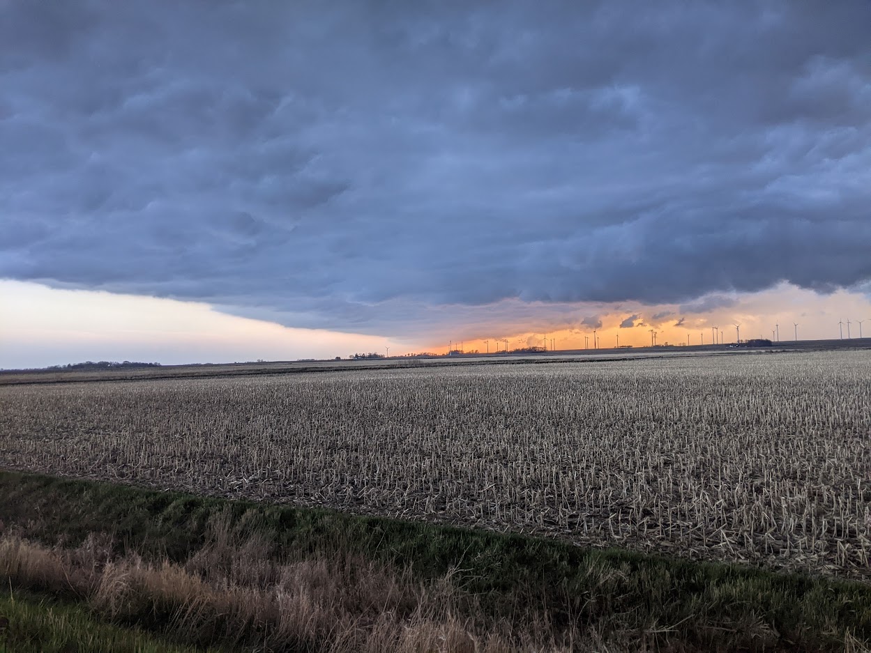
While stopped in Algona, we got some nice pictures of an anvil from this line of storms along the triple point. Note how displaced the anvil is from the base of the storm. This is a testament to the strength of the upper-level winds and wind shear associated with this pattern.

Taken 5:24 pm near Algona, IA
Algona is about halfway between Spencer and Mason City in the map below. These were the storms along the triple-point, and this radar image was taken at 6:04 pm.

Des Moines radar at 6:04 pm 4/28/2025. Created with NOAA Weather & Climate Toolkit
Around 6pm, Ben Keil, another grad student, said "guys, if we are gonna chase these storms, we need to leave NOW!" Everybody agreed, and we were off!
Part 2: The Chase - Algona to Kensett
The individual storms along this line were tracking northeast around 50 mph, but the line itself was moving due east. Our method was to get out ahead of the line, see if any of the individual cells dropped a tornado, and then continue moving east to avoid getting rained/hailed on. The towns that we did stop at eventually reported ~1" hail, so it was a good thing we kept moving east!
We took various stops and pictures along the way. Below are a few of my favorites. These are in chronological order, from left to right. Click on each image to enlarge.

East of Bancroft, near 150th Ave and 360th St. 6:13 pm

East of Lake Mills, near 465th St. and Bluebill Ave. 7:05 pm
 Near Thomas Farmstead at Wheelewood Road and 410th St. 7:54 pm
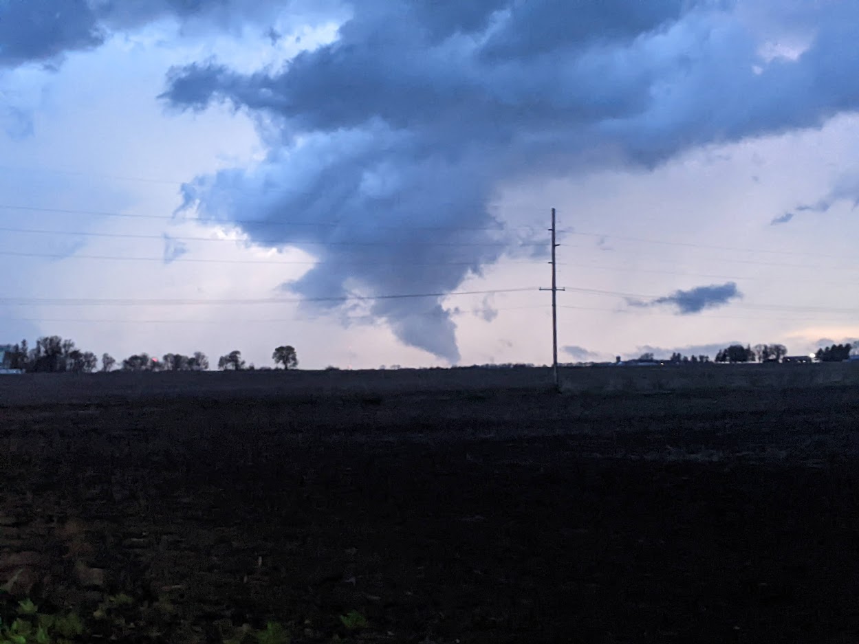 South of Kensett near 400th St. and Hwy 65. 8:20 pm
The last one is NOT a tornado! It is "scud," which are non-rotating clouds underneath a thunderstorm that can be mistaken for tornadoes. Still, it is the most tornado-like scud I've ever seen, and I wouldn't be surprised if there was a little rotation. But certainly not enough to qualify as a tornado - even a very weak one.
Part 3: The Drive Back - Kensett to Ames
Our drive back was illuminated by lightning from a severe-warned thunderstorm that tracked right over Ames. Seeing lightning from the outside of a storm is always such a treat, because it allows you to see the billowing structure of the cumulonimbus cloud. We crossed some wet roads but avoided any precipitation. It was a great way to end a nice day with friends.
I've still yet to see a tornado, but I'm addicted to the hunt! There's still plenty of time left in tornado season, so if I'm not too busy with research and finals I should have some additional chances.
Charlie